


With a Godzilla El Niño Emerging, Humanity Sleepwalks into its Next Crisis
Based on our reaction times to previous crises, humanity may be in a wee bit of a pickle
This definitely has the potential of being the Godzilla El Niño.
Those are the words of NASA Jet Propulsion Laboratory climatologist Bill Patzert, made back in August of 2015 when he sought to describe the immensity of disruption that the emerging 2015 El Niño was about to cause.
Godzilla, if anybody is unfamiliar, is the Japanese lizard-like film monster that emerges from the ocean to spew its "atomic breath" (a devastating beam of radiation and plasma) upon cityscapes, while otherwise wreaking havoc upon anything unfortunate enough to be in its path. Any and all military technology thrown at Godzilla are quickly proven ineffective, the only respite coming via unexpected and benevolent other monsters that proceed to slap Godzilla back in its place.
Application of the "Godzilla" label to the weather phenomenon was essentially another way of identifying a "super" El Niño (a colloquialism for the more scientific "very strong" category), a supercharged and extreme weather event that pushes global temperatures to previously unseen levels. Although the subsequent 2018-2019 and 2023-2024 El Niños weren't worthy of the moniker, what's been rapidly developing in the Pacific ocean the past few weeks and months has been ringing alarm bells amongst those that study the event, so much so that not only has the Godzilla moniker been dusted off, but the impending climate disaster the world is about to experience is expected to be amongst the strongest – if not the strongest – El Niño the modern world has ever seen.
Coupled with the not-disappearing-anytime-soon Strait of Hormuz crisis and the increasingly dire fuel situation in Russia (which has spent many years as one of the world's largest exporters of fuel products), it would appear that with the SARS-CoV-2 pandemic being the first ripple, the era of catastrophic rolling disasters may very well be upon us.
Lurking beneath the ocean's surface...
The name El Niño was first bestowed upon the extreme weather event by Peruvian fishers in the 1800s who, upon noticing that warm water tended to arrive around Christmas time, thereafter associated the weather event with something rather inexplicable to the casual outsider: the baby Jesus (don't ask, it's a South American thing). It wasn't until the 1970s though that scientists began to understand the global nature of the event, thereafter piecing together not just its various weather patterns but also the historical impacts previous iterations had visited upon the world.
Emerging every two to seven years, and lasting between nine and 12 months, El Niño is the warm phase of the El Niño Southern Oscillation (ENSO) – a key driver of global climate – through which heat is released from the Pacific ocean, La Niña being the cool phase in which heat is absorbed. Neutral conditions exist when neither of the former are present and sea surface temperatures are about average.
In short, during the neutral state steady trade winds blow from the east to the west, in the process pushing warm surface water exposed to sunlight to the west. The warm water forms what is called the Western Pacific Warm Pool, fuelling precipitation and thus rainy climates in Norther Australia and Indonesia, and conversely a relatively cool climate in Peru and other eastern parts of the Pacific.
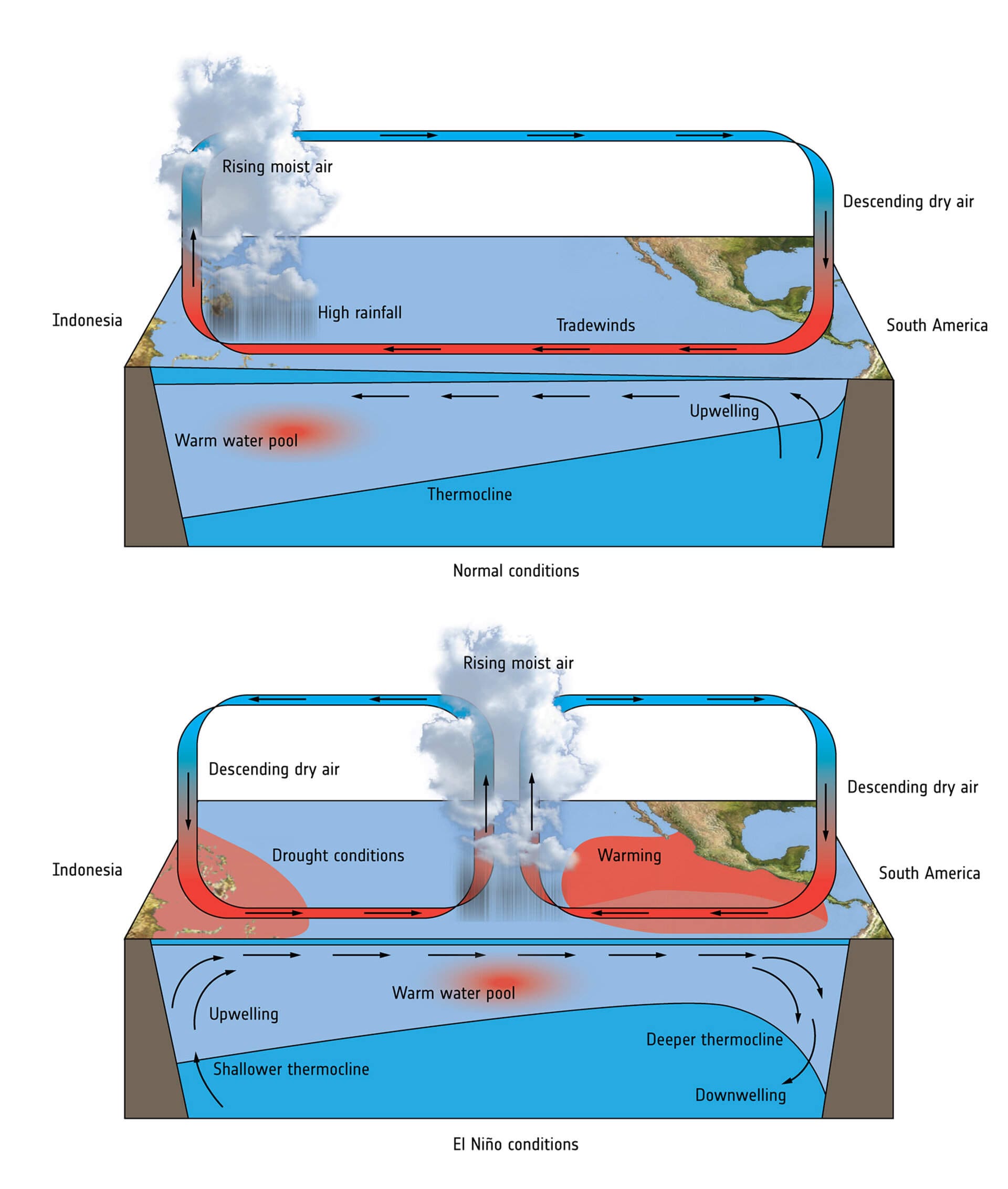
During the El Niño phase the trade winds weaken, resulting in the warm water that was normally pushed to the west to be shifted towards the east, in turn disrupting ocean circulation and blanketing most of the tropical Pacific with warmer water. The time lapse video below shows the increasing sea surface temperature along the Equatorial Pacific since late-April of this year in comparison to the average.
![Time lapse video of the "NOAA Coral Reef Watch Sea Surface Temperature Anomaly [°C]" for May, June and July](https://storage.ghost.io/c/d9/c3/d9c3ae66-3c63-49da-b4d3-18e56974e2b1/content/images/2026/08/archive_crw_ssta_global.gif)
The true engine of the El Niño weather event lies beneath the ocean surface though, the bottom section of the time lapse video below showing a side view of the Equatorial Pacific to a depth of 500m, depicting warmer water migrating and building toward the surface. The strong, warm anomaly migrates via what is known as a Kelvin wave, which is pushed below the surface to the eastern and central regions, the area where it then begins its rise to the surface.
![Time lapse video of the "ARMOR3D Subsurface Temperature Anomalies [°C]" from mid-April to late-July](https://storage.ghost.io/c/d9/c3/d9c3ae66-3c63-49da-b4d3-18e56974e2b1/content/images/2026/08/armor_subsfc_ssta_enso.gif)
With the tropical Pacific being a large basin, and with a super/Godzila El Niño being akin to a "pressure release valve" whereby accumulated warm water and energy in the Pacific is released, a lot of the heat from the warm water is sent up into the atmosphere, leading to an increase in the global mean surface temperature, convection changes, altered atmospheric circulation, and an array of high and low pressure areas. That all then leads to altered weather patterns and climate perturbations across the world linked to surface temperature changes, droughts, changes in precipitation patterns, and more, including what is essentially a six to 12 month long "mini global warming" event.
Somnambulist is us
Although the writing had already been on the wall for some time, it wasn't until June 11th that the United States' National Oceanic and Atmospheric Administration (NOAA) declared that El Niño had developed in the tropical Pacific, upon which it issued an El Niño Advisory. And although it's still early days yet, and although the phenomenon is still a few months off from its peak, it's already looking as if what's brewing in the tropical Pacific is a supercharged El Niño that's going to dole out varying degrees of devastation upon various parts of the world.
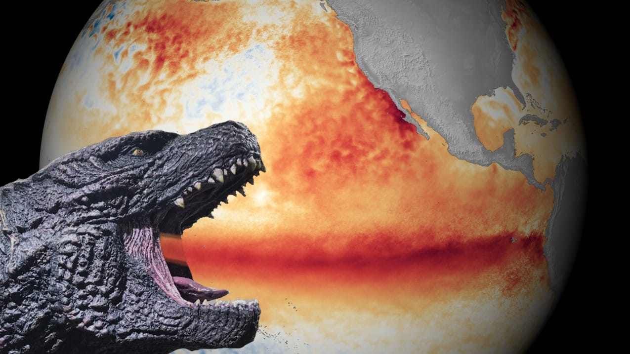
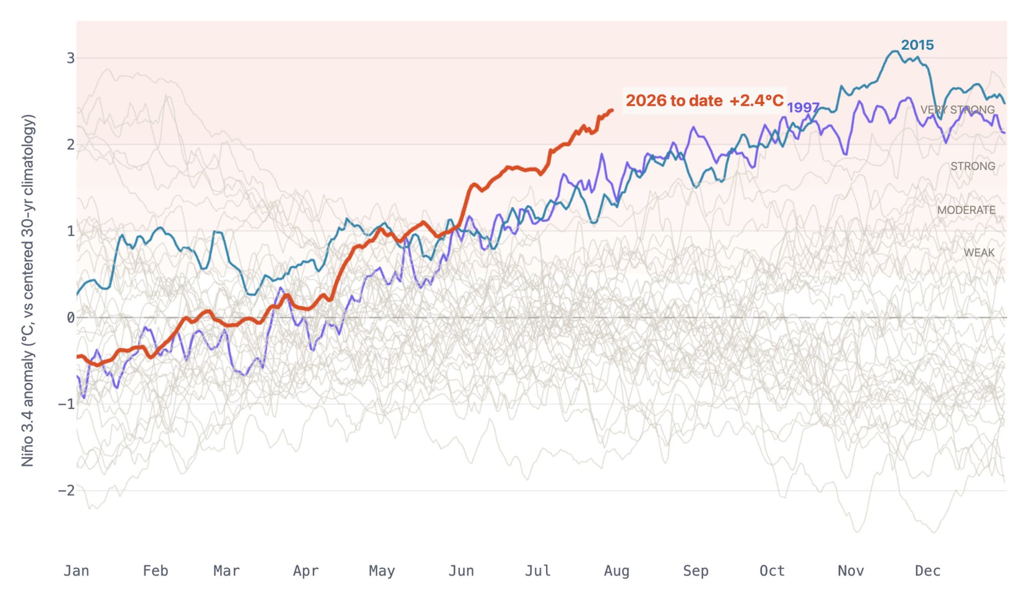
To be sure, although it's of course impossible to predict the exact circumstances that will occur during the upcoming El Niño, previous patterns and emerging evidence hint at the sheer immensity that might be in store for the world. For starters, if we look at the sea-surface temperature in the area used to monitor and define El Niño and La Niña events – the Niño 3.4 region of the equatorial Pacific (5°N–5°S, 170°W–120°W, roughly the left half of the warmed body of water seen in red in the feature image up top) – it can be seen that as of July 30th the region has reached 2.4°C above the baseline, achieved more than two months earlier than that level's previous record set in 2015.
But to get a better idea of just how off the charts the current situation and forecasts are, data from July 7th shows sea-surface temperature in the Niño 3.4 region to have reached 3.63 standard deviations above the 1991-2020 baseline, a 1-in-7000 event that did in fact require an extension of the previous chart's y-axis from just two days earlier when the deviation had by then "only" reached 3.4.
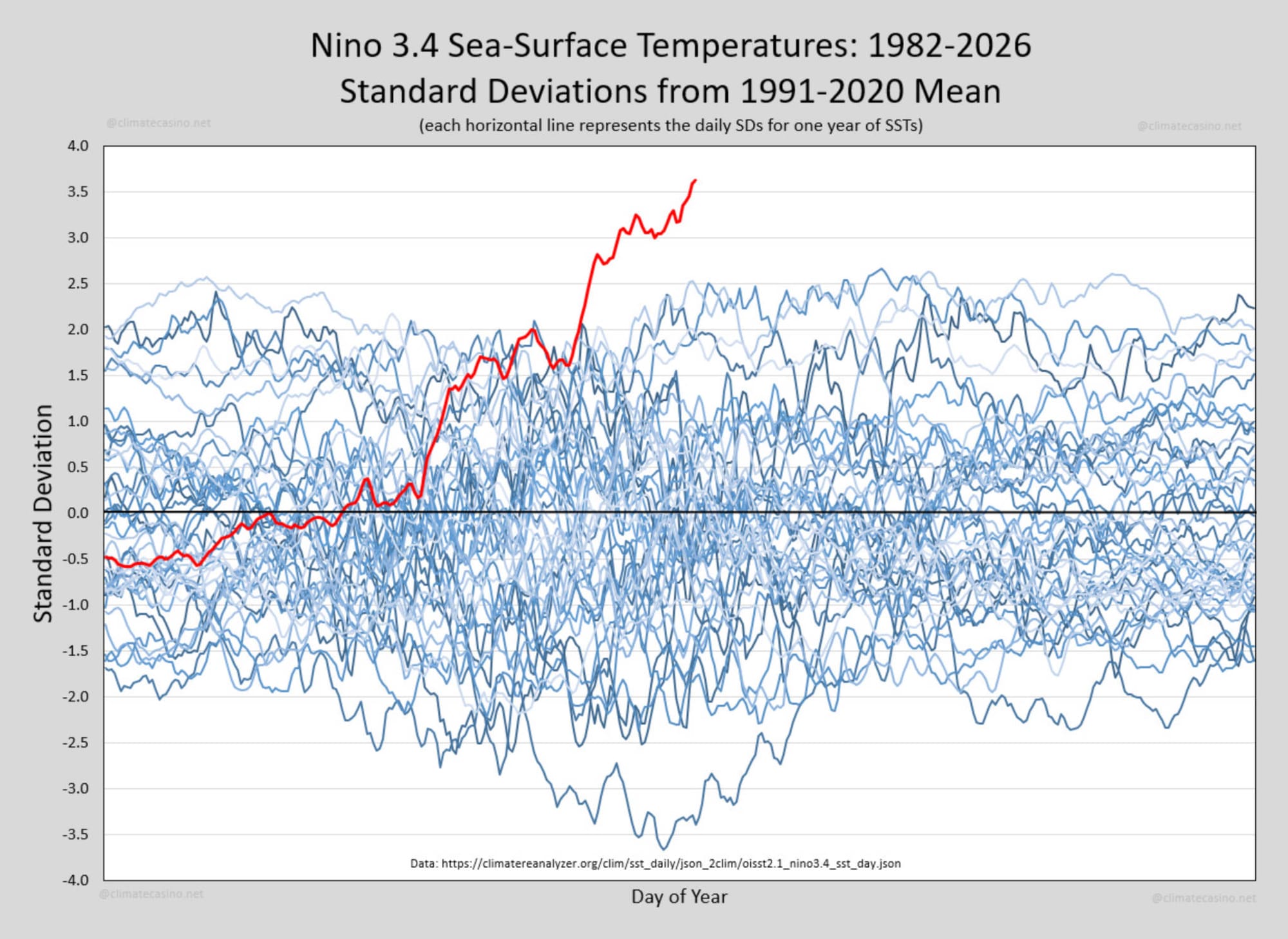
In a similar vein, on July 31st the Nino 3.4 sea-surface temperature set the 63rd consecutive daily record high for the Nino 3.4 region, surpassing the previous day's record by well over 1.0°C.
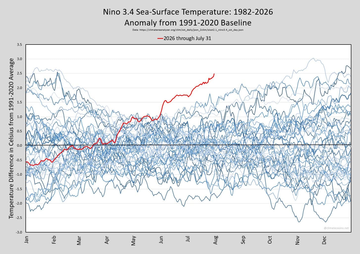
So not just setting records but completely departing from the range of previous observations, indicating that what's coming down the pike is likely to be stronger – and likely more disastrous – than anything seen in recorded history.
It's from here that the euphemisms to describe the strength of the upcoming El Niño come into play, the NOAA having forecasted an 81% chance that the world is about to experience a very strong El Niño (aka a super/Godzilla El Niño), entailing a massive discharge of thermal energy from the ocean's depths into the atmosphere.
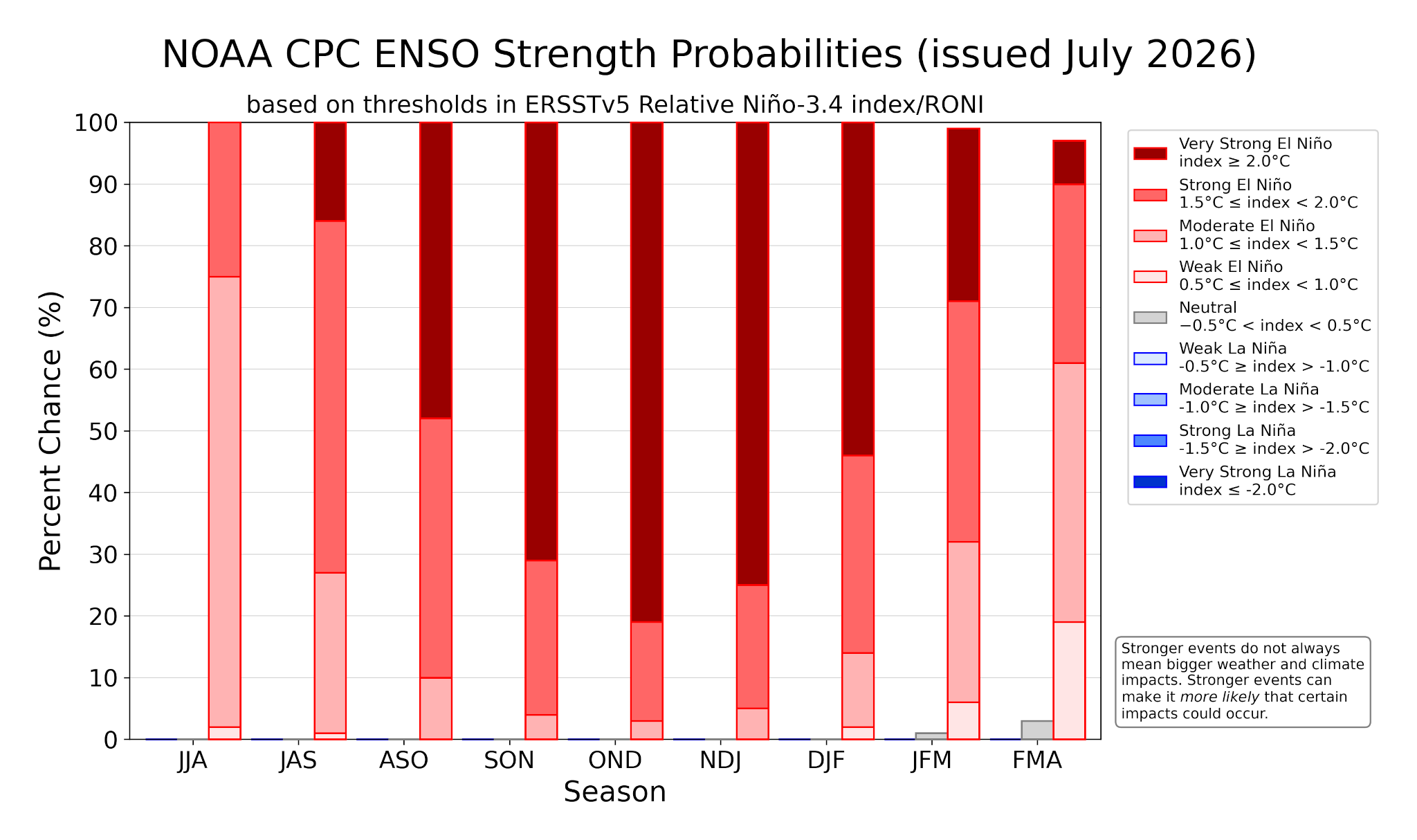
Weaker El Niños (between 0.5°C and 1.0°C) generally cause little impact on the world, entailing localized weather shifts with slightly wetter winters in some areas and manageable dry spells in others. On the other hand, very strong El Niños (higher than 2.0°C) effectively entail a rewiring of the global "engine" in which a strengthened jet stream impacts weather patterns thousands of kilometres away, including local seasonal trends becoming overridden with extreme outlier events that present day infrastructure wasn't built to handle.
There's only been a handful of El Niños that have reached the very strong category since records began in 1950, the 1982-83 event causing Lake Mead (in Nevada/Arizona) to overflow, the 1997-98 event causing Indonesia's worst drought on record, and the 2023-24 event causing South Africa's worst drought in a century, the latter-most case leading to food assistance being necessary for more than 60m people.
But whereas the strongest ever observed El Niño – the 2015-16 event – reached a peak of 2.75°C, the weighted median of the various models applied to this 2026-27 El Niño lands in at a staggering 3.6°C, with the highest end of the highest model reaching a whopping 5.5°C.
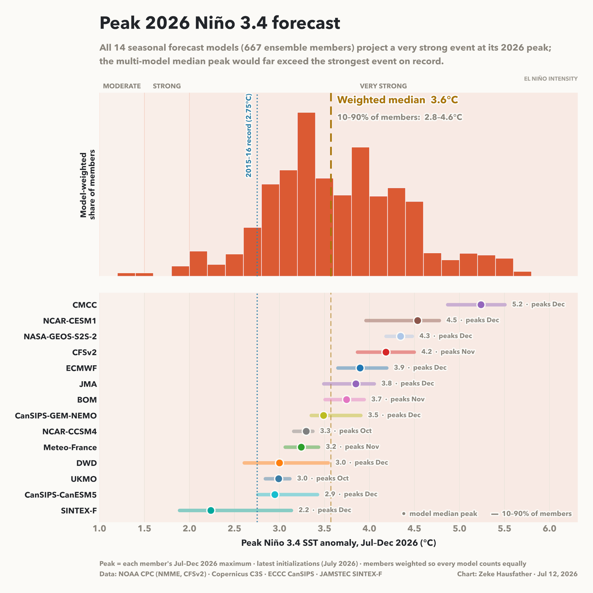
Upon comparing the projected range of the currently brewing El Niño to previous iterations, it's understandably hard for those who pay attention to such things to not get flashbacks of January/February 2020 when the majority of the people in the world dismissed and ignored all concerns and warnings and thus sleepwalked into a pandemic disaster, to go along with more recent flashbacks of not just four months ago but also to, well, yesterday, when, following the United States' on/off attacks on Iran and effective "closure" of the Strait of Hormuz (and thus curtailment of exports of raw crude, petrol/gasoline, diesel, natural gas, nitrogenous fertilizers, helium, sulphur, etc.), the world is sleepwalking into another calamity, this time what is likely to be a global recession if not depression.
With the kind of reaction times the vast majority of people – and modern industrial civilisation itself – apply to slow-moving train wrecks, it's hard not to designate sleepwalking-into-disaster as the defining trait of our present time.
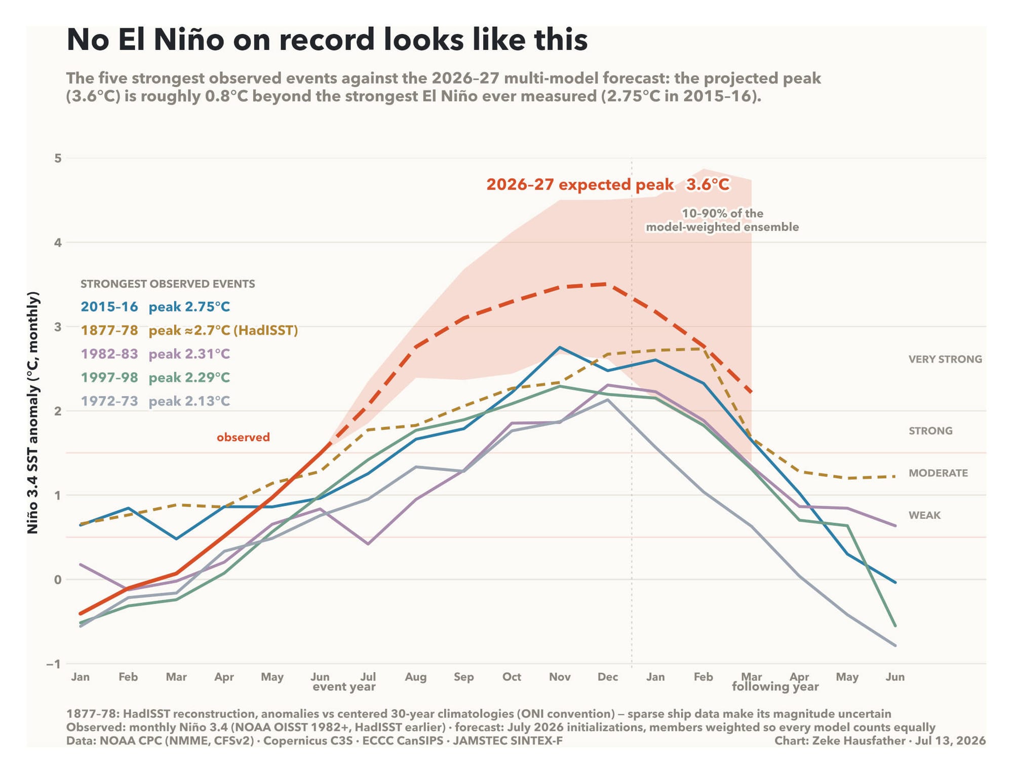
Because as can be seen in the next graph, no historical analogue exists for what's currently permeating in the tropical Pacific, the attention given to this upcoming calamity being drowned out by the attention being given to other currently unfolding calamities (the Strait of Hormuz crisis, the Russian invasion of Ukraine, wildfires in Spain/France, drought in the UK, etc.).
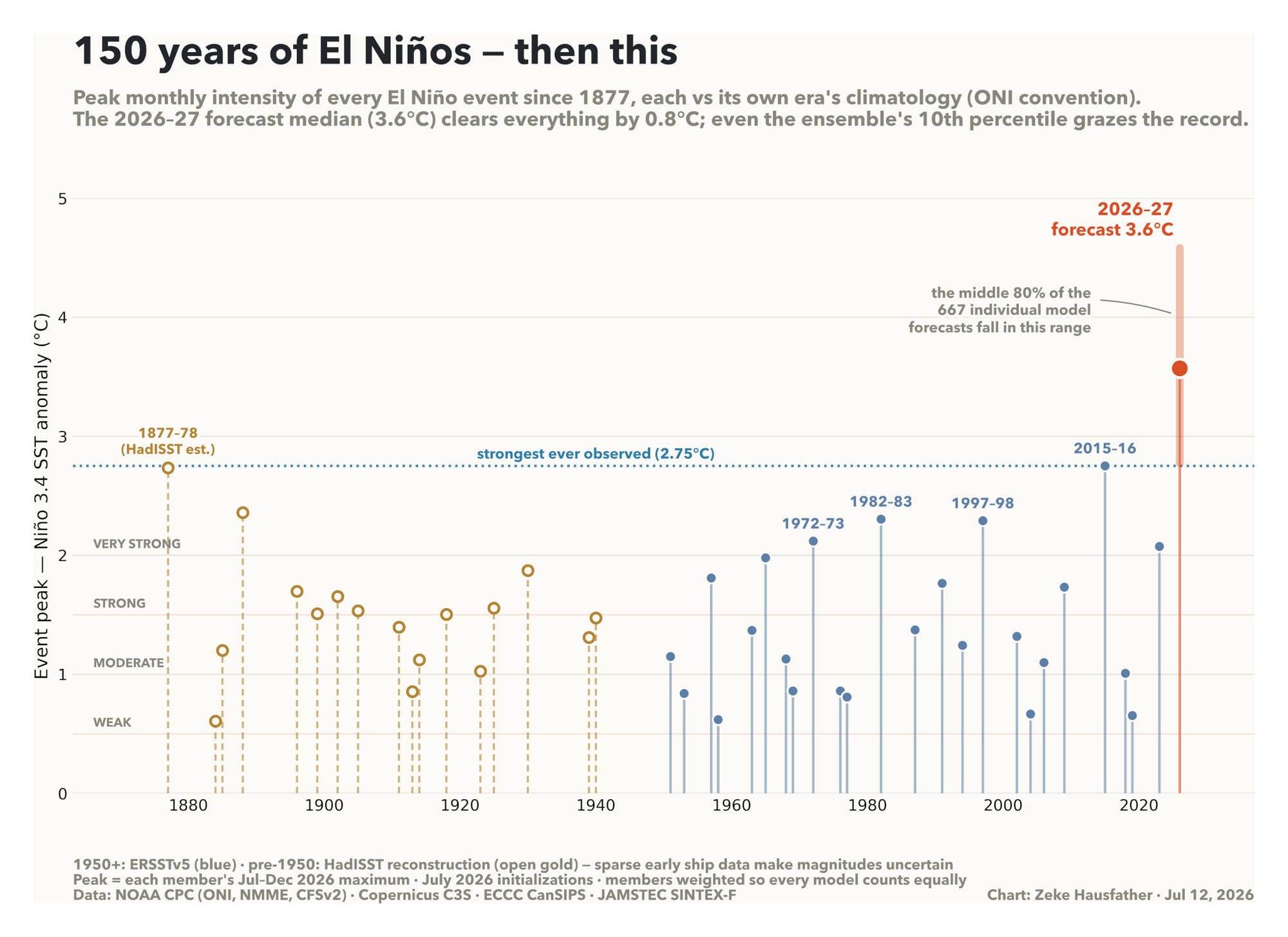
So while this El Niño will result in textbook impacts – albeit supercharged in strength and in all likelihood longer-lasting – it's also all but surely to crush the record-setting 2023-24 El Niño in which global temperatures remained above the 1.5°C 1850-1900 pre-industrial baseline for an entire year. In fact, with the NOAA having stated that "for every degree Celsius of El Niño warming in the central equatorial Pacific (or the Niño 3.4 region, to be precise), the global average surface temperature rises by 0.07°C (0.13˚F), with a delay of 2-3 months", there's a 35% chance that early-2027 may see global temperatures surpass 2°C for an entire month for the first time in recorded history (which are currently between 1.4°C and 1.5°C).
The reason for that record-breaking month not emerging until 2027 is due to the "stair step" upward trajectory that El Niños take, a process whereby the buildup of heat in the Pacific is passed through to the atmosphere over a period of months. It's for this reason that the latter half of 2026 will experience sustained anomalous tropical/subtropical warmth and that 2027 will get the amplified heatwaves that will not only make 2027 into the hottest year on record (which 2026 may itself end up achieving, even though it's typically the year following the events that breaks global temperature records), but also the first year that global annual temperatures breach 1.7°C above the 1850-1900 pre-industrial baseline (before they drop back down to the backdrop of pre-existing and historically unprecedented 1.5°C range, possibly 1.5°C+ on a ~permanent basis).
But of course, high temperatures aren't all this El Niño has in store for us. Fortunately though, and with lessons having been thoroughly learned from previous El Niños, the SARS-CoV-2 pandemic, etc., national and local governments, as well as people in general from all around the world, are pulling out all the stops to do all they can to prepare our regions and communities to withstand the array of El Niño-related disasters piling up in front of us.
Oh, wait.

















Comments